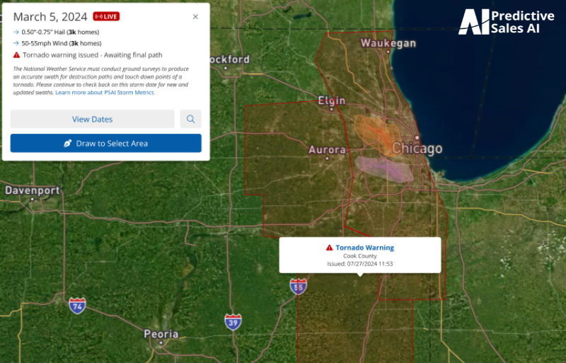
Key Components of the Tornado Tracking:
- Tornado Warnings: Displayed over county outlines and issued by the NWS, these warnings remain active for five days or until replaced by official tornado path data.
- Official Tornado Paths: Shown with gradient layers indicating severity on the Enhanced Fujita (EF) Scale, these paths provide detailed information. Warnings are updated to reflect the tornado’s EF rating if final path data is available within five days.
- Tornado Sightings: Real-time icons appear at the exact locations of reported tornado sightings, offering immediate insights into ongoing events.
Leveraging NWS Data:
After a tornado, the NWS conducts thorough data collection and analysis, typically taking 2-3 days but up to a week for major outbreaks. This ensures our platform reflects the most accurate and detailed information about the tornado's impact.
Extensive Historical Data:
Our platform’s historical tornado path data dates back to 2015, with select events from as far back as April 27, 2011. This comprehensive database aids in strategic decision-making by providing precise historical paths.
Importance of Ground Surveys:
NWS meteorologists perform detailed ground surveys to assess damage and assign an EF rating. This process involves pinpointing the tornado’s path and evaluating damage based on 28 specific indicators, ensuring precise classification.
Empower Your Marketing with Advanced Insights:
PSAI’s tornado tracking feature enables informed decision-making. If you need specific data or support, our team is here to help with personalized assistance and manual report generation. Contact us anytime to leverage these insights for your marketing strategies and stay ahead of the storm with PSAI.